
The route of Monte Agudo is a natural walk through the forests of the Cies Islands.We begin the tour at the information booth next to the pier, taking the road out to the right, toward the beach Figueiras. When you reach a crossroads we go straight to the foot of Monte Agudo high. Then, on a fork, turn left to head to a bird observatory with views of the rugged coastline of the islands, facing the ocean. This is an ideal place to see hundreds of seagulls that populate the Cies Islands....
Sendero homologado entre O Porriño y Redondela, con un desnivel de 400 m.
General interest A little network of trails that allows us to walk up and discover Mount Santa Tegra in depth. The main route, known as the Volta Promonte (PR-G 122), on the top of the mountain, is accompanied by other smaller trails known as Camiño de Citania (1), Atalla Vello (2), Camiño da Fonte da Cal (3), Camiño do Concheiro (4), Camiño do Carro e da Cruz do Home (5) and the Camiño das 14 revoltas (6).You can...
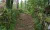
Arquitectura tradicional / Etnografía / Interese paisaxísticoThe route starts at the Alto do Confurco, located in the parish of Cans. At the beginning there are several wooden stairways and boardwalks to help us over some very uneven land, while passing by the stream of Couso that once fed the seven Mills of Laxe.From this point, the route winds through vineyards, meadows, cornfields, fountains and villages; an enjoyable and beautiful mosa...
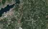
Landscape interestThis itinerary skirts the municipal borders of Vigo across its mountainous side, giving remarkable views of the city and the ria. It is a route designed to show people from this large city the natural environment that spreads out just a few metres from their homes. A series of forest parks have been located in parishes in Vigo District which, equipped with everything necessary for leisure and rest, are decisive in this pathways massive succ...
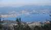
Landscape interestA circular pathway that joins up places with local historical interest, forest parks and extraordinary viewpoints. We should especially highlight mills like Muíño do Corviño and Muíño da Ponte do Río, and peaks like Penedo da Pucha, Penide and A Pedra que Fala. The culminating point of the route is the A Caseta viewpoint with extraordinary views over Val de Louriña, Vigo Ria and the hills surrounding Vig...
El espacio protegido abarca el estuario del río Miñor cerrado casi completamente por la playa de A Ladeira, de más de un kilómetro de longitud. En este tramo costero de fuerte presión humana como zona marisquera y turística se mantienen las marismas de A Foz, en las que confluyen con las mareas además del Miñor los riachuelos Groba y Belesar.El observatorio de Sabarís dispone de amplias ventanas y material telescópic...
This pilgrimage route was very important in the Middle Ages and was used by pilgrims from the westernmost lands of Portugal, among which include those from overseas countries who arrived to the Portuguese ports to reach Compostela.From Portugal they crossed the River Minho to A Pasaxe boat in A Guarda, O Rosal continuing on to the Monastery of Oia. From there, they continued to Baiona, Nigrán and Vigo up to Redondela, where this way came together with Portuguese Way from Tui.
Parece un lago. La ensenada final de la ría de Vigo de casi ocho kilómetros de longitud por cuatro de anchura se ve reducida en el estrecho de Rande a unos 700 metros. Ese es además su límite en profundidad, pues una buena parte de la cubeta desagua durante la bajamar y otra parte son aguas superficiales. Verde es la llanura que se descubre con las mareas, rica enmariscos bivalvos como las ostras de Arcade y aves acuáticas. Pero también rica en litera...
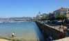
Circular route of 11.4 km in length, with a medium level of difficulty, ideal for people passionate about their nature and contact with the sea.The start of this tour is located in the tourist office near the beach Ribeira. We walked down the Paseo de Alfonso IX spotting the fishing port and continue parallel to the sea to the beach in Santa Marta.Upon arrival, we cross the pedestrian crossing and turn right to get into the rise of wooden riverwalk Baiña River, 550 meters...